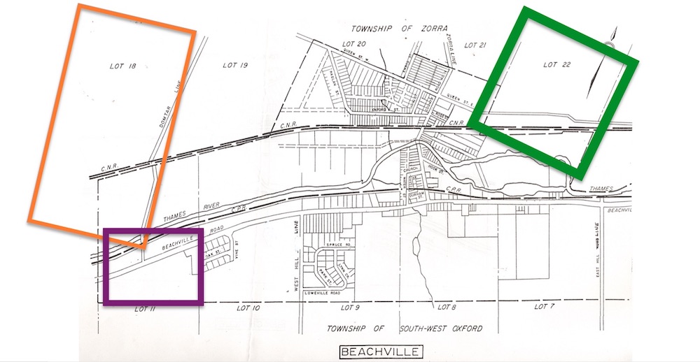
Quarrying West of the Village: 1860 Onwards

Unknown Date
Source: Beachville District Museum Reference Library
At the centre of this map is the Village of Beachville. Above the Canadian National Railroad tracks (marked C.N.R.) are lots numbered 18 to 22. Lot 18 is seen to the west, and Lot 22 is on the village’s east side. These lots were all part of North Oxford (now Zorra Township). Below the Thames River and the Canadian Pacific Railroad tracks (marked C.P.R.) are lots 7 to 11. These lots were part of West Oxford Township (now South-West Oxford Township). Lot 7 was to the east, and Lot 11 was to the west. The orange rectangle shows where Thomas Downing Sr. purchased land at Lot 18 to begin his quarry operation. The smaller, purple rectangle around Lot 11 shows where Alex Bremner’s land was. At Lots 19 and 20, Sandford Canfield attempted to quarry building stone in the late 1800s. The green rectangle around Lot 22 shows where Thomas Downing and the Dark brothers originally quarried stone in the 1850s and where Cole & Hacker mined grey limestone later in the 1800s.

