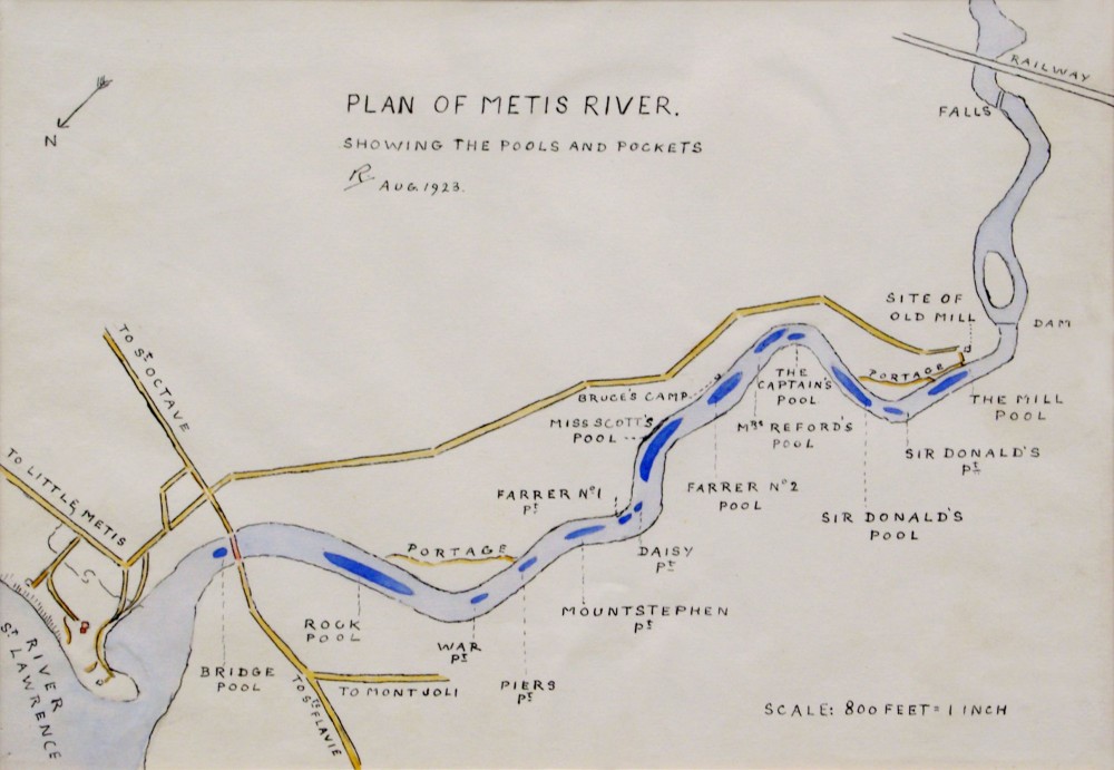
Plan of the Metis River by Lady Aileen Roberts

Lady Aileen Roberts
Plan of Metis River, August 1923
Watercolour; Chinese ink; paper
Les Amis des Jardins de Métis Collection
NAC: 1997.15
The salmon rivers of Québec are very different from one other. They vary depending on the flow of the river, the soil and geology and the landforms that each river traverses. The Metis River is fast-flowing and shallow. Its headwaters are the Mitis lakes 55 km to the south. The river flows north to the St. Lawrence, picking up flow from the streams and rivers that feed it on its way down.
Before the hydroelectric dams were constructed, the salmon had a fairly short spawning ground, from the mouth of the river 4 km upstream to the falls. Most of the pools were in the middle stretch of the river, where the river snakes through a deep chasm.
As the Atlantic salmon ascend the river, they congregate in pools that are formed by the currents, boulders and stones in the river bottom. This is where fishermen are likely to have the greatest success in getting a salmon to rise to the fly. Each pool is different. And on most rivers, every pool is baptised by fishermen.
Lady Aileen Roberts drew this map from hand, illustrating each of the pools that had been baptised over two generations. The pools and pockets took the names of the river’s most regular and successful fishermen and some of its notable geographic features:
-Mill Pool (near to where the seigneurial flour mill was located)
-Sir Donald’s Pool (named after Sir Donald Smith)
-Mrs. Reford’s Pool (named after Elsie Reford)
-The Captain’s Pool (origin unknown)
-Farrer No 1 Pool (after Gaspard Farrer, George Stephen’s lawyer and investment counsellor at Baring Brothers, in London)
-Farrer No 1 Pocket
-Mount Stephen pocket
-Miss Scott’s Pool (whose identity is a mystery)
-Rock Pool
-Bridge Pool (near to the bridge over the river)

